SoilWise Geopackage
Soil Profile Form
Open
To open the Soil Profile custom forms, go to the Layers panel, right‑click the soilprofile layer, and choose Open Attribute Table from the context menu.
Tip
For further information on the custom forms, consult the documents Customized Attribute Forms in QGIS and Navigating GeoPackage Tables via Forms
Edit
A Soil Profile does not contain any geometry. To enable editing through forms, follow the instructions provided in the document Editing Records Through a QGIS Form.
REQUIRED fields
id: primary key (auto-incrementing)Begin Lifespan version: DATETIME (default: today)Valid From: DATETIME (default: today)isderived: BOOLEAN (default: 0)isoriginalclassification: BOOLEAN (default: 1)
ID Group
Fields
-
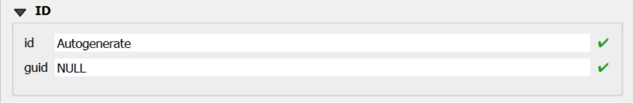
id- Primary AUTO_INCREMENT INTEGER PRIMARY KEY; it’s the required identifier for GeoPackage tables and is assigned automatically on insert. -
guid- Global identifier in UUID format, stored as text. The field is optional. It’s automatically managed via triggers.
Important
On opening, the ID group is collapsed: there is no need for manual editing, as both fields are system‑managed (the id by the SQLite engine and the guid by triggers), reducing errors and ensuring identifier consistency over time.
Dynamic Form Behaviour Based on Is Derived
The Soil Profile data-entry form must adapt dynamically according to the value of the field soilprofile.isderived, which determines whether the profile is Observed (0) or Derived (1). This behaviour follows the INSPIRE Soil data model and is strictly enforced in the GeoPackage through database triggers and CHECK constraints.
Is Derived = 0 → Observed Soil Profile
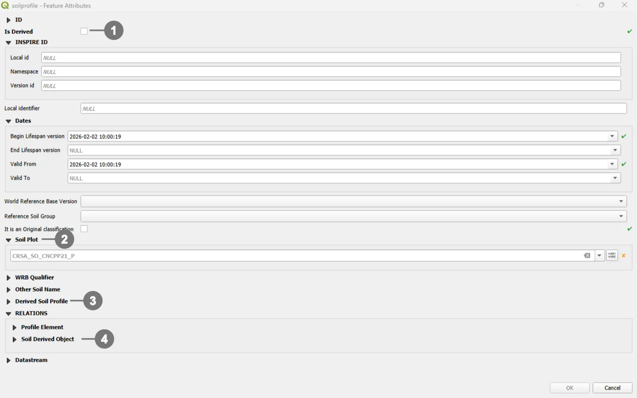 When users select Observed - The checkbox is unchecked ①
The form automatically shows the elements related to point‑location and to the contextual relations available for observed profiles.
The Soil Plot section becomes visible, ② allowing the selection of the associated soilplot.guid.
The Derived Soil Profile section (representing the isderivedfrom relation where the observed profile may appear as guid_related) also appears,③ along with the SoilDerived Object relation area ④.
Attempts to store a NULL or invalid location are blocked by database triggers, ensuring data consistency.
Interface elements specific to derived profiles—such as derived‑only constraints or soil‑body‑percentage definitions—do not appear while the profile is in Observed mode.
Database logic prevents these derived‑only relations from being created for an observed profile.
Is Derived = 1 → Derived Soil Profile
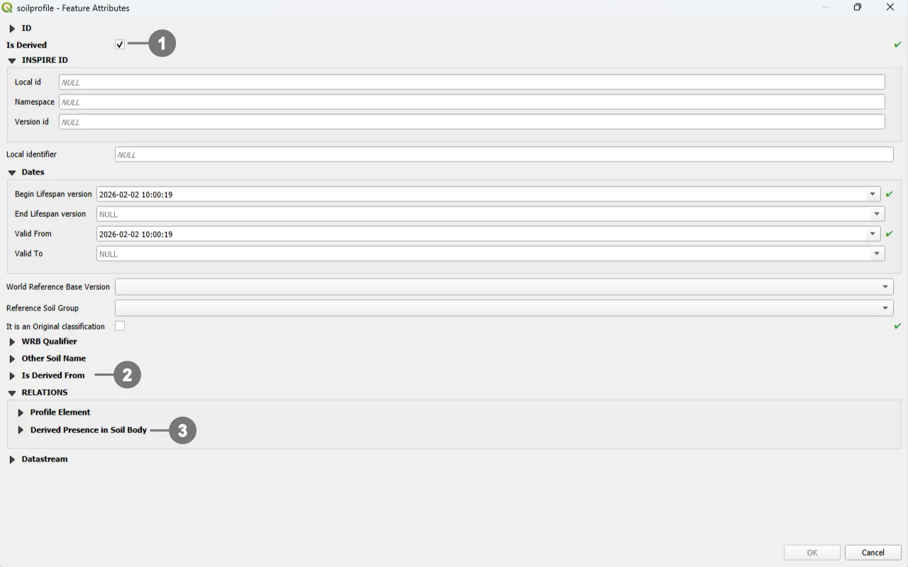 When users select Derived - The checkbox is checked ①
The form adjusts by hiding all location‑related components, including the Soil Plot section, since derived profiles are not point‑located. Any non‑NULL value in the location field is rejected by database triggers.
In this mode, the form exposes only the relational structures applicable to derived profiles:
the Is Derived From section, ② which represents the association to observed profiles through the isderivedfrom table (where the derived profile appears as guid_base)
the Derived Presence in Soil Body section,③ corresponding to the derivedprofilepresenceinsoilbody table, used to express the percentage‑based presence of the derived profile within a Soil Body.
These interface elements reflect the constraints, type‑coherence checks, and consistency rules enforced at database level.
INSPIRE ID Group
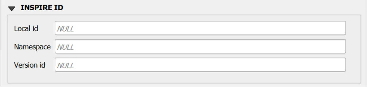
An INSPIRE ID is the external unique identifier assigned to each spatial object in INSPIRE datasets; it ensures uniqueness and persistence and allows external applications to reliably reference the same object over time. The identifier must not be changed during the object’s life cycle; it can also be published as a URI to facilitate web-based referencing. 1
Fields
Local id— Local identifier assigned by the data provider; unique within its namespace.Namespace— Namespace that uniquely identifies the data source/domain of the spatial object.Version id— Identifier of the specific version of the object; optional (voidable) and used to distinguish different versions of the same object.
Important
These fields are not mandatory, but filling them out is strongly recommended: they help uniquely identify the record in forms and across data exchanges.
In particular, localid + namespace form a stable identifier; versionid helps track changes over time.
Editing Child Elements in QGIS Forms
Editing child elements directly within a parent form improves data quality and speed: it keeps users in context, guarantees referential integrity through predefined relations, and reduces errors by enforcing database rules at the moment of entry. In your GeoPackage, several relationships are validated by triggers and codelist checks, so capturing child data where it belongs (inside the parent form) closely aligns UI behavior with DB constraints.
Sub Form
Use the following buttons to manage child layers during data editing.
Toggle editing mode for child layer ① enables editing on the related (child) layer embedded in the form; once active, you can add/modify/delete child records directly from the parent record’s view.
Save child layer edit ② commits the pending edits for the child layer to the GeoPackage. Use this to persist changes without leaving the parent form.
Add child feature ③ creates a new child record pre‑linked to the current parent (relation fields are auto‑populated by the form’s relation widget), ensuring correct foreign keys and preventing orphan rows.
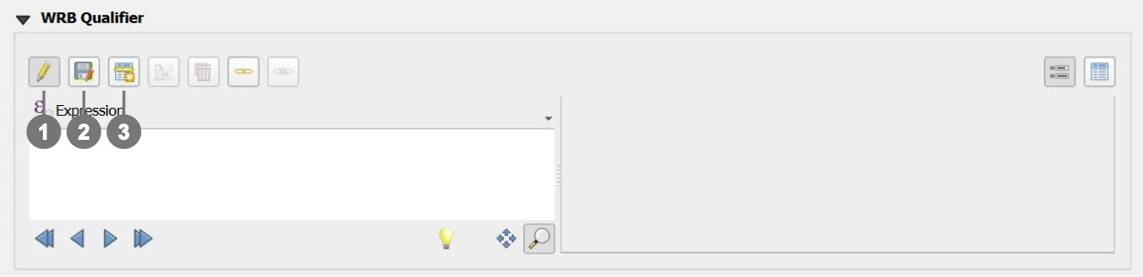
Sub Form WRB Qualifier
Purpose: attaches WRB qualifier groups to a soil profile with an explicit qualifierposition (ordering).
DB enforcement: triggers align wrbversion between profile and qualifier group, and ensure qualifierposition is unique per qualifierplace within the same profile.
Form hint: expose as a child list on the Soil Profile form; use Add child feature to add qualifiers in order, and Save child layer edit to commit.
Sub Form Other Soil Name
Purpose: stores additional soil names and related classification flags for a profile.
DB enforcement: codelist checks on othersoilname_type; GUID immutability; cascading rules via FK to soilprofile.
Form hint: present as a child panel in the Soil Profile form for quick insertion of multiple alternative names; Save child layer edit to persist
Sub Form Derived Soil Profile (Visible if isderived = TRUE) - Is Derived From (Visible if isderived = FALSE)
Purpose: records the association Derived Soil Profile (guid_base) → Observed Soil Profile (guid_related).
DB enforcement: triggers guarantee that guid_base points to a derived profile and guid_related to an observed one; duplicates of the same pair are prevented.
Form hint: embed this as a child table under Derived Soil Profile; use Add child feature to append observed sources and Save child layer edit to persist.
Constraints
- CHECK:
validfrom <= validto(BEFORE INSERT/UPDATE). - CHECK:
beginlifespanversion < endlifespanversion(BEFORE INSERT). - Observed/Derived location rule: if
isderived=1thenlocationmust be NULL; ifisderived=0thenlocationmust be NOT NULL (BEFORE INSERT/UPDATE). - WRB version membership:
wrbversion ∈ codelist(id)wherecollection='wrbversion'when not NULL (BEFORE INSERT/UPDATE). - WRB RSG + version coherence: if
wrbversiontargets a specific year,wrbreferencesoilgroupmust belong to the corresponding year collection (BEFORE INSERT/UPDATE). - GUID immutability and versioning refresh on UPDATE.
Attribute Reference
For an overview of the attributes used in the custom form, refer to the soilsite table documentation. It provides the key definitions and data types needed to correctly interpret the fields and configure the form within the data model.
Datastream Relationship
Since this table is relationally linked to a SensorThings Datastream, you can add further domain‑specific properties in an STA2‑compatible way by correctly populating the Datastream and Observation tables.
In practice, Datastream holds the series‑level context of the time series, while each Observation record carries the measurement‑level details, reflecting the SensorThings data model in which every observation is organized under a datastream.
Save
For a more comprehensive overview of form‑saving workflows, refer to the detailed documentation in Saving Edits in QGIS Forms.