SoilWise Geopackage
SoilWise Geopackage-so (SQLite3) — Tables & Schema Overview
This folder documents the database tables of the SoilWise INSPIRE Soil (SO) GeoPackage, delivered as an OGC GeoPackage implemented on top of SQLite3. 1 The schema combines:
- an INSPIRE Soil–oriented relational core (Site → Plot → Profile → Profile Elements), and a SensorThings-like observation layer (Datastream/Observation) to publish soil observations as interoperable time series (aligned with the repository scope and STA 2.0 draft direction). 2
This page provides a technical entry point: how the schema is organised, which entities are central, and which integrity constraints and triggers are enforced.
Relational Structure of the GeoPackage (INSPIRE UML + STA2 Transposition)
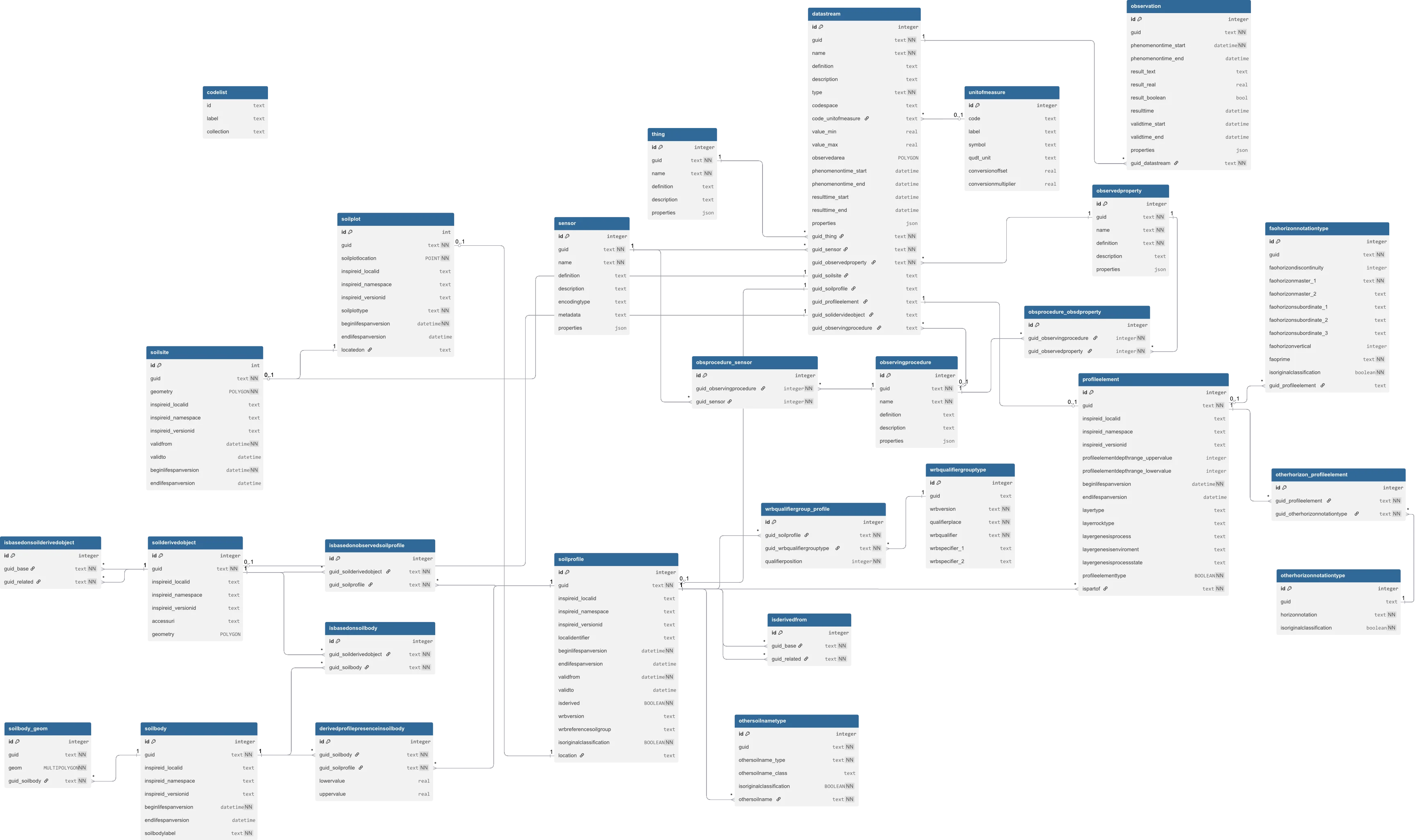
Tip
Click the image to see it full‑size for better viewing.
Quick index (main tables)
Links are relative to the current directory (
documentation/tables/).
If your filenames differ (e.g.,soilsite/index.md), update the link targets only.
Code lists / domains
- codelist — controlled values repository used to validate domains (INSPIRE codelists + local “Category” collections).
INSPIRE Soil core (Site → Plot → Profile → Element)
- soilsite — investigation site geometry (POLYGON) and purpose.
- soilplot — plot / sampling point (POINT), located on a Soil Site.
- soilprofile — soil profile (Observed vs Derived), linked to a plot (Observed only).
- profileelement — vertical elements (Horizon/Layer) belonging to a profile, with depth constraints and domain checks.
Observations (SensorThings-like)
- datastream — observation “channel”: what is observed (ObservedProperty), how (Procedure/Sensor), and on which Feature of Interest (FOI).
- observation — time-stamped results, constrained by
datastream.type(Quantity/Category/Boolean/Count/Text).
1) GeoPackage as a technical container (SQLite + OGC metadata)
A .gpkg file is an SQLite database that includes OGC GeoPackage metadata tables (e.g., gpkg_contents, gpkg_geometry_columns) to make layers directly usable in GIS software.
In this implementation:
- feature layers are registered in
gpkg_contents(per-table records), - geometry types and spatial reference metadata are registered in
gpkg_geometry_columns, - geometry columns are indexed (e.g.,
idx_soilsite_geom,idx_soilplot_geom).
Spatial reference: the schema registers and uses ETRS89 / LAEA Europe (EPSG:3035) for the main geometry layers (e.g., Soil Site polygons, Soil Plot points, SoilBody geometry).
2) Cross-cutting conventions (GUIDs, temporal validity, domains)
2.1 GUIDs: autogenerated and immutable
Most business tables expose a guid column (unique). If guid is NULL on INSERT, triggers generate a UUID-like lowercase value. Updates of guid are blocked by dedicated triggers.
2.2 Validity and lifecycle timestamps
Where required by the conceptual model, tables include:
validfrom/validtowith checks enforcingvalidfrom <= validto,beginlifespanversion/endlifespanversionwith consistency checks and automatic refresh ofbeginlifespanversionupon relevant updates.
2.3 Domain enforcement via codelist
Many domain attributes are not free text: triggers validate that the stored value exists in codelist.id for a given codelist.collection (e.g., SoilInvestigationPurposeValue, SoilPlotTypeValue, WRB/FAO codelists, and the local Category collection for categorical observations).
Implication: load the necessary codelist collections before inserting domain records.
3) INSPIRE Soil core backbone (Site → Plot → Profile → ProfileElement)
The schema follows the operational flow widely used for soil field/legacy datasets:
3.1 Soil Site (soilsite)
Represents an investigation area:
- geometry: POLYGON (
geometry), - mandatory
soilinvestigationpurposevalidated against codelists.
3.2 Soil Plot (soilplot)
Represents a plot / sampling location:
- geometry: POINT (
soilplotlocation), locatedonis a FK tosoilsite(guid)(plot belongs to a site).
3.3 Soil Profile (soilprofile)
Represents a soil profile, explicitly distinguishing:
- Observed profile (
isderived = 0): must havelocationNOT NULL, - Derived profile (
isderived = 1): must havelocationNULL.
Observed profiles link to plots via location → soilplot(guid) (with cascade delete).
WRB classification fields are guarded by consistency checks and codelist membership rules (including version-dependent collections).
3.4 Profile Element (profileelement)
Represents vertical subdivisions within a profile:
- belongs to a profile via
ispartof → soilprofile(guid)(cascade delete), profileelementtypeencodes:0= Horizon1= Layer
- depth constraints enforce coherent upper/lower limits and non-null depth information,
- additional triggers enforce field compatibility (e.g., layer-only vs horizon-only attributes; “geogenic” constraints).
4) Observations layer (SensorThings-like): Datastream + Observation
To manage soil measurements and indicators as time series, the schema implements:
4.1 Datastream (datastream)
Defines an observation stream:
- descriptive metadata (
name,definition,description), typeconstrained to{Quantity, Category, Boolean, Count, Text}with strict allowed combinations (UoM vs codespace vs bounds).- FK block: links to
sensor,observedproperty, optionalobservingprocedure(plus optionalthing). - FOI block: only one among SoilSite / SoilProfile / ProfileElement / SoilDerivedObject can be populated (enforced via CHECK).
- if
guid_observingprocedureis present, the pair (procedure, observedProperty) must exist inobsprocedure_obsdproperty(enforced by triggers).
4.2 Observation (observation)
Stores individual results for a datastream:
- each observation references
guid_datastreamand is unique per(phenomenontime_start, guid_datastream). - triggers enforce result “shape” and validity based on the linked datastream type:
- Quantity:
result_realNOT NULL; bounds enforced ifvalue_min/value_maxset, - Category:
result_textNOT NULL and must exist incodelistwherecollection = datastream.codespace, - Boolean:
result_boolean∈ {0,1}; other result fields NULL, - Count:
result_realinteger-like (numerically integral) plus bounds (if set), - Text:
result_textNOT NULL; other result fields NULL.
- Quantity:
Additionally, observation triggers keep datastream.phenomenontime_start/end synchronised to the MIN/MAX of linked observations.
4.3 Convenience view: view_observation
A dedicated view joins observations to their FOI context (site/plot/profile/element), and standardises output fields such as property name, procedure, UoM symbol, and type-specific numeric values. This is intended for reporting and extraction without re-implementing complex joins.
5) Minimal SQL examples
5.1 Traverse the core chain (Site → Plot → Profile → Element)
SELECT
  ss.guid AS soilsite_guid,
  sp.guid AS soilplot_guid,
  pr.guid AS soilprofile_guid,
  pe.guid AS profileelement_guid
FROM soilsite ss
JOIN soilplot sp        ON sp.locatedon = ss.guid
JOIN soilprofile pr     ON pr.location  = sp.guid
LEFT JOIN profileelement pe ON pe.ispartof = pr.guid;